Santorini is not photogenic. It is geometric. You do not need a geology degree to understand why every image of the island resembles every other image, but you do need to understand a handful of terms before the postcard stops feeling like magic and starts feeling like inevitability. What follows is a walkthrough — not of a place, but of the vocabulary that makes the place legible. Learn the words, and you will never look at a Santorini image the same way again.
Caldera
A caldera is what remains after a volcano collapses into the emptied magma chamber beneath it. Not a crater — craters are blown outward. Calderas fall inward. The difference matters, because it explains the shape: not a rim around a summit, but a rim around an absence. In practical terms, Santorini's caldera is a flooded basin roughly ten kilometers across, ringed by cliffs that rise several hundred meters on their inner faces and slope gently down to the sea on their outer ones. Everything the reader has ever seen photographed on Santorini — the white houses stacked on the edge, the sunset dropping into water, the perspective that flattens sky and sea into a single blue field — is happening on the inside face of a collapse. This is the term the postcard depends on. Nothing else in the vocabulary works without it.
The Rim
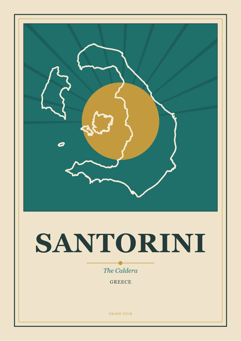
The rim is the surviving edge. It is not a circle; it is a crescent, open to the west and southwest, where the sea broke in when the roof of the volcano fell. Two large islands — the main one, and the smaller strip to its west — trace the arc between them. The rim is where every village worth photographing sits, and it sits there for a reason: the inner cliff face is the only side of the island that faces the water at a height. Everything else is either sea-level coastline or the mild outward slope of the surviving cone. When the reader hears "Santorini view," what they actually mean is a specific stretch of that inner rim. There are no other views. The rest of the island photographs like anywhere else in the Aegean.
 Santorini
The print from this article · from €29.95
View the print →
Santorini
The print from this article · from €29.95
View the print →
Aspect
Aspect, in geography, means the direction a slope faces. It is unglamorous vocabulary, but for Santorini it does most of the work. The inner face of the caldera rim faces west. West-facing means the light hits the cliff obliquely in the morning, straight on in the afternoon, and directly along the water in the last hour of the day. It also means the sun sets into the field of view — not off to the side, not behind the observer, but into the empty basin the caldera left behind. Every other Cycladic island has coastlines that face every direction, which means their views are democratic and slightly dilute. Santorini has a coastline that essentially faces one direction, and it happens to be the direction the postcard was invented to photograph.
The Minoan Eruption
The event that made the shape possible was a single Bronze Age eruption large enough to appear in the geological record across the Eastern Mediterranean. The precise date is debated within archaeology; the broad consensus places it in the middle of the second millennium BCE. What is not debated is the scale: the caldera we see today is the empty room the eruption left. Before it, Santorini was a taller, rounder volcanic island. After it, the island was a rim around water. Every essay written about the postcard view of Santorini is, at bottom, an essay about a specific afternoon in prehistory. This is the term the reader can invoke to short-circuit any conversation that treats the island as merely picturesque. It is not picturesque. It is a wound with a village on the edge.
Nea and Palea Kameni
At the center of the flooded basin sit two small dark islands — "new burnt" and "old burnt" in Greek — the visible tops of the volcano quietly rebuilding itself in the middle of its own collapse. They are not decoration. They are the reason the composition works. Without them, the caldera view would be an unbroken plane of blue between the observer and the far horizon: an oceanic view, not a compositional one. With them, the eye is given a middle ground — dark, textured, close enough to read, far enough to give scale. Every Santorini image the reader has ever mentally filed is using those two black shapes as a compositional anchor, whether the photographer knew it or not. Remove them, and the postcard falls apart into wallpaper.
Thera and Therasia
The main island is Thera. The strip along the western edge of the crescent, across the caldera, is Therasia. Together they trace the surviving edge of the pre-eruption cone. When you stand on the rim at Oia and look southwest, the far arc you see across the water is not the horizon — it is Therasia, a few kilometers away, at roughly the same elevation you are standing on. This is the second reason the postcard works. The eye is given a container: a rim on the near side, a rim on the far side, and a basin between. A photograph of open sea is a wallpaper. A photograph of an enclosed basin is a composition. Santorini is one of the very few coastal views in Europe in which the far bank of the view is the same island as the near bank.
Cliff Terracing
The villages on the rim — Fira, Firostefani, Imerovigli, Oia — are not built on top of the cliff. They are built into the top forty or fifty meters of it, stacked in narrow terraces that follow the contour lines. This is not aesthetic choice. It is a response to the fact that the rim has almost no flat land: the outer slope begins immediately behind the villages, and the inner cliff drops immediately in front of them. What looks in photographs like an artful cascade of white cubes down the cliff face is a purely mechanical response to available surface. The picturesque, here, is a by-product of the buildable. This is worth naming precisely because it flatters no one to admit it, and every drawing of Santorini ever produced is a drawing of an engineering constraint.
Cycladic White
The whitewashed walls are a Cycladic tradition older than the tourism industry and older than the postcard: lime wash reflects heat, seals porous stone, and is cheap. On Santorini, where the underlying rock is dark volcanic tuff, the contrast reads violently. Dark cliff, white village, blue sea. Three values, no gradient. This is why the island photographs and draws so cleanly: the palette is already reduced to poster levels before the artist arrives. A studio drawing Santorini has fewer decisions to make than a studio drawing almost any other European destination, because the island has already made them. Everywhere else, the poster artist has to simplify a landscape into three colors. Here, the landscape has already done the simplification.
The Sunset Alignment
Because the caldera opens to the west, the sun sets into the basin. Most "west-facing coasts" have their coast running north–south, which means the sun sets somewhere off to the side, along the coastline. Santorini's rim curves. From different points along that curve — Fira, Imerovigli, Oia — the sunset falls into different sections of the basin, and from Oia in particular it falls along the sight line down the long axis of the crescent, past Therasia, into the horizon. This is why Oia is the sunset village and Fira is the daytime village. The postcard is not one postcard. It is a set of postcards at different points along a circular arc, each one differently aligned with the position of the sun at a specific hour.
Vantage
The rim is a viewing balcony above a stage, and every element on the stage — the two Kameni islands in the middle, the arc of Therasia across the water, the vertical drop directly below the observer — was placed by geology, not by design. The reader who has held the previous terms in mind will notice something uncomfortable: nothing about the composition is accidental, and nothing about it is authored. The island composes itself. Studios that draw it — including this one — are, in a real sense, tracing something that was already drawn. Which raises the next question, and it is not a question this piece will answer: if the composition is not authored, what exactly is the poster artist doing when they sit down to draw it. That is where the real work of looking at Santorini begins.
FAQ
Why does every photograph of Santorini look basically the same?
Because the view is not a choice — it is a constrained geography. The rim is a crescent facing one direction, the two Kameni islands sit in a fixed spot in the middle of the basin, and the villages have almost no flat land to build on. Any photographer working from the rim is composing with the same anchor points at roughly the same angles. The uniformity of Santorini images is not a failure of photography. It is what happens when a landscape does most of the compositional work in advance.
Which village on the caldera has the best view?
There is no single "best," but there is a functional split. Oia sits at the northwestern tip of the crescent and receives the most direct sunset alignment down the long axis of the caldera. Fira, further south along the rim, has a broader daytime view across to Therasia and the Kameni islands, with the sun higher and off to the side. Imerovigli, between them, has the highest elevation on the rim. Choose by hour of day rather than by reputation.
Was Santorini always shaped like a crescent?
No. Before the Bronze Age eruption in the middle of the second millennium BCE, Santorini was a taller, more or less circular volcanic island. The eruption emptied the magma chamber, and the roof of the volcano collapsed inward. The sea flooded the resulting basin, leaving the crescent of Thera and the smaller island of Therasia as the surviving edges of the pre-eruption cone. The famous shape, in other words, is a ruin.
Is the volcano actually still active?
Yes, though quietly. The two small dark islands at the center of the caldera, Nea Kameni and Palea Kameni, are the visible tops of the volcano rebuilding itself in the middle of its own collapse. They emerged from the sea in successive eruptive phases over the last two thousand years and remain the geologically active center of the system. What looks like a purely decorative middle-ground in the postcard view is, in fact, the ongoing continuation of the event that created the view in the first place.
Why is the sunset famous specifically on Santorini and not on other Greek islands?
Most Greek coasts run in a way that puts the setting sun off to the side of the view. Santorini's rim curves west, and the caldera opens directly into the sun's path in the last hour of the day. That means the sunset does not just happen "over the sea" — it drops into a bounded basin, framed by the far rim of Therasia and anchored by the Kameni islands. Other Greek islands have sunsets. Santorini has a composed sunset.
What makes Santorini easier to draw than other Mediterranean islands?
The palette is already reduced. Dark volcanic tuff at the cliff face, whitewashed lime plaster on the villages, deep blue in the basin and the sky — three values with almost no gradient between them. A poster artist typically has to simplify a landscape's tonal range down to something printable. Santorini has done that simplification in advance. Combined with a fixed set of geographic anchor points, this leaves the artist with fewer decisions than almost anywhere else in Europe.
Are the whitewashed houses traditional or a modern tourist look?
The whitewash is a genuinely old Cycladic tradition, not an invention of the tourism era. Lime wash reflects heat, seals porous local stone, and was for centuries the cheapest available treatment. Its visual dominance on Santorini specifically is amplified by the contrast with the dark volcanic rock underneath, and its consistency across villages has been reinforced by later planning conventions. The look is authentic in origin and curated in enforcement. Both things are true.
New city prints and 10% off your first order.
One email now with your code. No noise after.