A plan of Paris printed in 1920 sits on the desk in front of us, and the first thing to say is that it is not a map. It is a portrait made in the language of cartography — north oriented conventionally upward, the Seine drawn as a slow diagonal from southeast to northwest, the boulevards fanning from the river the way ribs fan from a spine. The city is river-defined; the geometry insists on it. Everything a plan of that decade chose to show, and everything it chose to leave out, was an argument about what Paris was supposed to mean.
That distinction matters, because when a buyer today searches for a "plan of Paris 1920 print," what they are usually looking for is not navigational utility. They already have a phone. What they want is a printed object that behaves like a portrait of the city — dense, considered, printed with intention, hanging on a wall the way a painting hangs. The 1920s produced a great deal of such printed matter, and treating any of it as a mere map understates what it is doing.
We draw cities before we write about them, and drawing this one has taught us to read its old plans the way one reads a piece of writing: for register, for what is emphasized, for what is quietly demoted.
The 1920 Plan of Paris Was Never a Map. It Was a Portrait.
A map exists to answer a question. A plan of Paris printed in 1920 exists to compose an image. The vocabulary is cartographic — scale bar, compass rose, arrondissement numerals, hatch marks for green space — but the grammar is pictorial. Nothing sits on the paper by accident.
Consider the register first. Plans printed in that decade were, almost without exception, lithographic. That is a specific printing technology with specific consequences. Lithography rewards flat colour, clean line, and small, uniform typography set close to features rather than sprawled over them. It punishes gradient. So a 1920 plan tends to look calm on the wall: pale ground, one or two accent colours for water and vegetation, black lines doing the structural work, place names running along boulevards rather than jumping across them. That is a printerly choice pretending to be a mapmaking choice.
Consider next what is elevated. Monuments and gardens tend to be drawn slightly out of scale — the Louvre a little longer than it is, the Jardin du Luxembourg a little more geometric, the Place de la Concorde a little more emphatic. Bridges are usually numbered or named individually, one by one across the river, which is not something a navigational map would waste ink on. The reader is being walked past them.
Consider what is quieted. The industrial belt outside the old *enceinte* is typically shown as an outline, then filled with texture rather than detail. The railway approaches are drawn but rarely labelled with the same care as the boulevards. The port activity along the Seine — real, working, loud in 1920 — is almost never depicted with its cranes or barges. The plan has decided that the working city is not what this image is for.
The result is a document that reads as neutral and is not. It is a piece of civic self-portraiture, printed in the register that Paris of that decade preferred: rational surface, ornament restrained, the past inherited from the nineteenth century still visibly the frame within which everything else happens. To buy a 1920 plan and hang it is to hang a specific idea of the city, not the city.
That is not a criticism. It is a definition. A print is honest about being a print. A map that pretended otherwise would be worse.
The Seine Is the Only Line That Was Never Redrawn
Almost everything on a plan of Paris can be re-legended. Arrondissements can be re-coloured. Boulevards can be renamed, and are — the same street can carry three different names across three different printings within a decade, following political weather. Squares are re-labelled after events. Metro stations appear, migrate, and merge as the network grows. Buildings come and go. The type itself gets rethought every generation.
The Seine does not move.
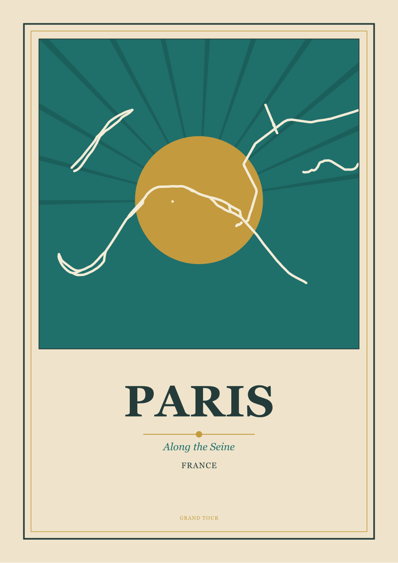
It is the one geometry that every plan of the city, in 1720, in 1820, in 1920, and in the plans a studio draws now, has had to accept without editorial input. Its diagonal — that long, uneven curve running from the southeast quadrant through the historic core and away toward the northwest — is the compositional spine of the entire image. Everything a plan does, it does in relation to that line. When we draw Paris in the studio, our first pencil marks are the Seine's meander and the two islands sitting inside it. The rest of the city is built against that.
This is why plans of Paris from the 1920s look, at a glance, more legible than plans of many other European capitals of the same period. The river gives the eye a single strong diagonal to organise everything around. Boulevards read as radial or perpendicular against it. The Right Bank and Left Bank are not just political categories; they are the two halves of a printed composition. A designer can put the title cartouche in one bank, the compass rose in the other, and the balance holds.
The Haussmann interventions, most of which were more than half a century old by 1920, had already imposed the second-most stable thing on the plan: the long straight boulevards cutting across the older tissue. By 1920 those boulevards were themselves being drawn as if they had always been there. Which, on the timescale of a printed plan, they had.
Everything after the Seine and Haussmann is annotation. The metro lines get added. Neighbourhoods are shaded and unshaded. The typography of place names changes with fashion. But the fundamental image — river running diagonally across the page, straight boulevards keying off it — was fixed. A plan of Paris in 1920 is not free to compose itself. It is composing within a geometry the city itself dictated.
To understand a 1920 print of the city, then, look first at what could not be moved. The river's shape is the ground truth. The typography, the colours, the emphasis on monuments — all of that is style, and style dates. The Seine does not.
 Paris
The print from this article · from €29.95
View the print →
Paris
The print from this article · from €29.95
View the print →
What a Modern Print of a 1920 Plan Owes the Original
Search results for "plan of Paris 1920 print" resolve to two very different objects, and it is worth being precise about which is which.
The first is a scanned facsimile. Someone photographs or scans an original 1920 plan, adjusts the tone, cleans the paper, and prints it. That is a reproduction. Whether it is a good one depends entirely on the quality of the source and the honesty of the print. A poor scan reproduced at large scale on thin paper is a poor object. A high-resolution capture from a well-preserved original, printed at scale on a substrate that respects the original's flatness, can be an excellent one. The value of a facsimile is proportional to how faithful it is. It has no editorial position of its own. It is a photograph of a document.
The second is a re-drawing. A studio takes the geographic ground truth — the river, the coastline of the islands, the grid of the boulevards, the position of the gardens and the monuments — and draws it fresh, in the register of the golden age of travel posters and printed plans. The reference to 1920 in that case is not a facsimile claim. It is a stylistic claim. The plan is drawn *as if* it were printed then: the palette restrained, the typography set with the discretion of that era, the composition organised the way a printer of that decade would have organised it. The geometry is contemporary and accurate. The dress is period.
The two objects answer different desires. A facsimile answers the desire to own the printed history itself. A re-drawing answers the desire to hang a portrait of the city composed in that visual language, without the compromises of a hundred-year-old sheet — the yellowing, the folds, the printing errors, the sometimes cramped composition of a plan that was made to be folded into a pocket rather than framed.
Our own position is the second. We draw European cities from their real geometry, sourced from open geographic data, and we compose them in the language of the printed plans and travel posters of the early twentieth century. When we make a plan of Paris in that register, the river's meander is drawn from actual coordinates; the boulevards are placed where they are; the arrondissement lines follow the current administrative boundary. What is *stylised* is the surface: the palette, the line weight, the typography, the way monuments are handled, the restraint of the ornament. That is what a modern print of a 1920 plan can honestly be — a truthful geometry dressed in a period vocabulary. Prints of Paris and other European cities drawn in this way live in our shop.
The honest label matters. A print that claims to be a 1920 plan and is a modern re-drawing should say so. A print that claims to be a facsimile and is a re-touch should say so. The buyer is entitled to know which object is on the wall.
This started as a note on how to shop for a printed plan and turned, somewhere in the second section, into a small essay on what a plan is at all. Plans of Paris from the 1920s look calmer on the wall than most contemporary maps because they were designed as printed objects first and reference documents second. Understanding that is most of the work of choosing one.
FAQ
What does "a 1920 plan of Paris" actually refer to?
The phrase covers printed plans of the city made in and around the 1920s — most of them lithographic sheets showing the arrondissements, the Seine, the major boulevards and monuments, sometimes with the metro network overlaid. They were produced for use, but their visual register is closer to portrait than to navigational map. Today the phrase is also used for modern re-drawings composed in that period's visual language, which is a different object from a facsimile of an original sheet.
Is a 1920 plan of Paris still geographically accurate today?
For the fundamental geometry, largely yes. The Seine's course through the city, the position of the islands, the Haussmann boulevards, the main squares and gardens, and the arrondissement layout of that period are still legible in the current city. What has changed is the metro network, the periphery, the ring road, and many named details on individual streets. As a portrait of the historic core, a 1920 plan is close to what a visitor sees now. As a routing document, it is out of date.
What is the difference between a facsimile and a re-drawn plan?
A facsimile is a reproduction of an existing 1920 sheet — scanned or photographed, then reprinted. It carries the original's virtues and its wear. A re-drawing is a new plan drawn from contemporary geographic data and composed in the visual register of the 1920s: period palette, period typography, period restraint. The geometry is current; only the styling references the era. Both are legitimate objects; they answer different questions about what the buyer wants on the wall.
Why does the Seine dominate every plan of the city so completely?
Because the river is the one element that cannot be re-designed. Its meander runs diagonally across the frame, and every other feature of the city — the two banks, the islands, the bridges, the axes of the boulevards — is placed in relation to it. Any plan of Paris, in any decade, has to accept that diagonal as its compositional spine. Designers can choose colour, typography, and emphasis, but they cannot choose where the Seine goes.
What paper and format suits a plan of Paris print at home?
The 1920 register was built for flat, matte lithography with restrained colour. Modern prints that respect that lineage read best on uncoated or lightly coated matte paper rather than gloss, which fights the flat palette. Larger formats — roughly A2 upward — let the boulevards and the river breathe; below that, the fine typography of place names starts to collapse. A simple thin frame, ideally without a heavy mount, keeps the composition doing the work rather than the framing.
Is a plan of Paris different from a Paris travel poster?
Yes, though they belong to the same family. A travel poster foregrounds a single image — a monument, a view, a symbolic figure — and uses type as a headline. A plan foregrounds the whole city as a printed pattern, with typography embedded in the geometry rather than framing it. Both were produced in overlapping decades and share a palette and a printing technology, which is why they hang comfortably on the same wall.
Can a modern studio print honestly claim to be "in the style of 1920"?
It can, provided the claim is stylistic rather than historical. A modern re-drawing that borrows the period's palette, typography and compositional restraint, and that draws the city from real geographic data, is a truthful object as long as it does not misrepresent itself as an original 1920 sheet or a facsimile of one. The honest label is: contemporary print, drawn from current geography, composed in the visual language of that decade.
What should a buyer look at first when choosing a plan of Paris print?
Look at the river. The way a plan handles the Seine — the accuracy of its meander, the treatment of the two islands, the weight and colour given to the water — tells you most of what you need to know about the care behind the sheet. If the river is drawn well, the rest of the plan is usually drawn well. If the river has been simplified into a bland ribbon, the plan has been designed for volume rather than for the city.
New city prints and 10% off your first order.
One email now with your code. No noise after.